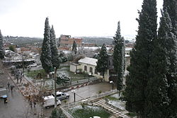
Oued Endja
Appearance
Oued Endja
وادي النجاء in arabic | |
|---|---|
Commune | |
 | |
 | |
| Country | |
| Province | Mila Province |
| Area | |
| • Total | 20.61 sq mi (53.39 km2) |
| Population (2008[1]) | |
| • Total | 19,739 |
| • Density | 1,000/sq mi (370/km2) |
| Time zone | UTC+1 (CET) |
Oued Endja وادي النجاء is a commune in Mila Province, Algeria. Redjas town is the capital. At the 2008 census it had a population of 19739.
There are 7 named mountains in Oued Endja District, with Koudiat Zouacha the highest point. The most prominent mountain is Djebel Essatour.[2]
References
[edit]- ^ "Recensement 2008 de la population algérienne, wilaya de Mila, sur le site de l'ONS" (PDF).
- ^ "Daïra Oued Endja Mountains". PeakVisor. Retrieved 2021-04-07.
36°30′00″N 6°04′17″E / 36.50000°N 6.07139°E

